


Stev 2.1 réel

trietsch
User
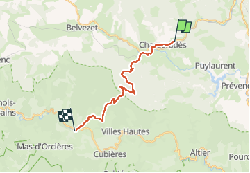

Length
18.2 km

Max alt
1413 m

Uphill gradient
529 m
Km-Effort
26 km

Min alt
1070 m

Downhill gradient
631 m
Boucle
No
Creation date :
2025-05-26 06:13:19.0
Updated on :
2025-05-26 12:12:07.942
4h47
Difficulty : Very difficult

FREE GPS app for hiking
 SityTrail
IGN / Geographical institutes
SityTrail Plus
The world is yours!
About
Trail Walking of 18.2 km to be discovered at Occitania, Lozère, Mont Lozère et Goulet. This trail is proposed by trietsch.
Positioning
Country:
France
Region :
Occitania
Department/Province :
Lozère
Municipality :
Mont Lozère et Goulet
Location:
Unknown
Start:(Dec)
Start:(UTM)
566474 ; 4933673 (31T) N.
Comments